SPOT-1985
Hello this is the start of a post
Project Background:
Sofar and its collaborators in the National Oceanographic Partnership Program (NOPP) Hurricane Coastal Impacts Project (NHCI) airdrop fleets of Spotter buoys ahead of hurricanes in the Atlantic Ocean and Gulf of Mexico. The Spotters make direct, real-time observations at scale of the extreme conditions generated by storms. This data enhances the government and coastal communities' efforts to understand, predict, and prepare for hurricanes.
On Wednesday, October 9th, Spotters airdropped in the path of Hurricane Milton made direct, real-time observations of the extreme conditions generated by the storm before it made landfall near Siesta Key on the Florida Gulf Coast.
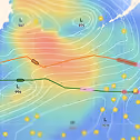
Below, we overlay NASA/NOAA GOES-16 satellite imagery of Hurricane Milton with the drift tracks of each airdropped Spotter (easternmost yellow pentagons) in the Gulf of Mexico. Spotters airdropped ahead of Hurricane Helene, which made landfall in northwest Florida in late September, are also visible (northernmost yellow pentagons).

SPOT-31243C passed particularly close to Hurricane Milton, recording significant wave heights of 35.8 feet. That translates to maximum wave heights of approximately 66.6 feet. SPOT-31243C also observed decreases in atmospheric pressure and sea surface temperature, which are caused respectively by the eye passing close to the Spotter and vertical mixing being induced by the storm.

On Tuesday, October 8th, the U.S. Naval Research Laboratory Scientific Development Squadron VXS-1 airdropped eight Spotter buoys, along with microSWIFTs and A-DWSDs, in the path of Hurricane Milton in the Gulf of Mexico.
The Spotters will make direct, real-time observations of the extreme conditions generated by the major hurricane before it makes landfall mid-week. Multiple Spotters deployed ahead of Hurricane Helene, which made landfall in Florida’s Big Bend region in late September, are also in position to make observations to the north of the storm.

The ground truth data collected by the Spotters will enhance efforts by coastal communities and government agencies — including the National Hurricane Center — to understand, forecast, and prepare for Hurricane Milton. The storm is expected to make landfall in Florida's Tampa Bay region.
On Thursday, September 26th, Spotters airdropped in the path of Hurricane Helene made direct, real-time observations of the extreme conditions generated by the Category 4 storm.
Below, we overlay NASA/NOAA GOES-16 satellite imagery of Hurricane Helene with the drift tracks of each airdropped Spotter (yellow pentagons) in the Gulf of Mexico. Watch as the southernmost Spotters drift extremely close to Hurricane Helene's eye wall.

SPOT-31995C (southernmost drift track) passed particularly close to Hurricane Helene, recording significant wave heights of 38.5 feet. That translates to maximum wave heights of approximately 71.6 feet, comparable to the height of a five-story building. SPOT-31995C also observed sharp drops in atmospheric pressure and sea surface temperature, which are caused respectively by the eye passing close to the Spotter and vertical mixing being induced by the storm.

SPOT-31995C travelled a great distance due to the chaotic conditions caused by Hurricane Helene. During the six-hour period when SPOT-31995C was closest to the storm, it drifted approximately 27 miles.
In the videos below, watch as the U.S. Naval Research Laboratory Scientific Development Squadron VXS-1 airdrops Spotter buoys into the Gulf of Mexico ahead of Hurricane Helene.
Video credit: Sofar Ocean / NOPP
On Tuesday, September 24th, the U.S. Naval Research Laboratory Scientific Development Squadron VXS-1 airdropped 13 Spotter buoys, along with microSWIFTs and A-DWSDs, in the path of Hurricane Helene in the Gulf of Mexico. The Spotters will drift freely ahead of the storm and make direct, real-time observations of the extreme conditions that it generates. As of 9am Eastern, multiple Spotters had already observed maximum wave heights of 25+ feet.

The ground truth data collected by the Spotters will provide critical information about the real-time conditions created by Hurricane Helene. These observations enhance the government and coastal communities' efforts to understand, forecast, and prepare for the storm.
Hurricane Helene is currently a Category 2 storm and is expected to make landfall as a potential Category 4 storm in the Florida Panhandle late Thursday, September 26th.
On Wednesday, September 11th, five Spotters airdropped in the Gulf of Mexico collected and transmitted direct, real-time observations of the extreme conditions generated by Hurricane Francine. The Spotters, which were deployed on Tuesday, September 10th, passed near the Category 2 hurricane shortly before it made landfall in Louisiana.
Below, we overlay NASA/NOAA GOES-16 satellite imagery of Hurricane Francine with the drift tracks of each airdropped Spotter (yellow pentagons). Watch as the Spotters move westward towards the intensifying hurricane before it reaches the Gulf Coast.

SPOT-31983C (easternmost buoy) passed particularly close to Hurricane Francine, observing significant wave heights of approximately 20 feet. That translates to maximum wave heights of approximately 40 feet. Ground truth observations like these are extremely rare and highly valued by forecasters and coastal communities tasked with predicting and preparing for extreme storms.
On Tuesday, September 10th, the U.S. Naval Research Laboratory Scientific Development Squadron VXS-1 airdropped five Spotter buoys, along with microSWIFTs and A-DWSDs, in the path of Hurricane Francine in the Gulf of Mexico. The Spotters will drift freely in the Gulf and sample the extreme conditions generated by Hurricane Francine in real-time as it approaches the coast.

The ground truth data collected by the Spotters will provide unique insights about the actual conditions generated by Hurricane Francine before it makes landfall. These in situ observations will enhance efforts to understand, forecast, and prepare for the storm.
Hurricane Francine is currently a Category 1 storm and is expected to make landfall in Louisiana on Wednesday, September 11th. The storm is forecasted to bring dangerous winds, rainfall, storm surge, and flooding to the Gulf Coast region.