

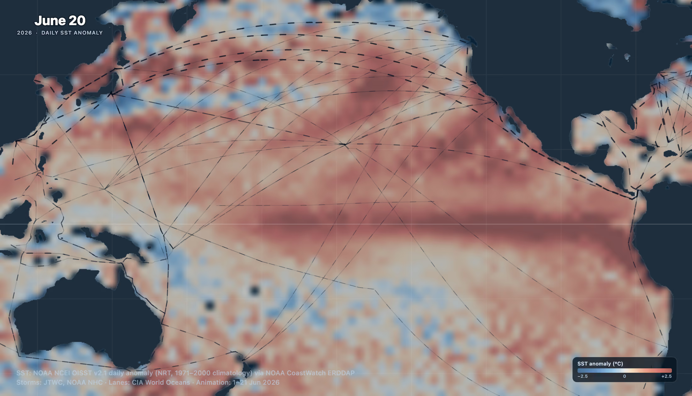
NOAA's Climate Prediction Center issued an El Niño Advisory in June 2026, confirming El Niño conditions are present in the tropical Pacific and forecast to strengthen into the Northern Hemisphere winter. The 2026 Pacific typhoon season has been active by historical standards, with multiple Category 4 and 5 storms developing in rapid succession, including Super Typhoon Sinlaku in April and Super Typhoon Bavi in July.
Sofar Ocean's global network of Spotters makes direct, real-time observations of ocean conditions in the path of these storms as they develop. This ground truth data, significant wave height and barometric pressure recorded directly from the ocean surface, enhances Sofar's own marine weather forecasting and supports maritime operators, coastal communities, and government agencies working to understand, predict, and prepare for the high sea states these storms generate.
This page will track Spotter observations and real-time insights across the 2026 El Niño storm season as they occur.
August was an active month across the Pacific with 18 storms, spread from the South China Sea to Central America.
Sofar Ocean Spotters caught them as they tore through the basin.Starting the month off strong, SPOT-33176C sat 20 km from Typhoon Dolphin's core and measured a 12.12 m significant wave height, nearly seven times the height of a person. Three weeks later SPOT-31867C rode out Typhoon Saudel 71 km from the center with significant wave heights peaking above 8 m.
This El Niño is still building with NOAA declaring a 95% chance for a ‘very strong’ El Niño through the end of the year.
Sofar Ocean's global Spotter network delivers real-time marine weather and in-water wave data from some of the most remote stretches of open ocean. Spotters measure wave height and sea conditions right where the storms are, filling the gaps that satellites and forecast models can't cover on their own. Spotter data feeds into Wayfinder, Sofar's dynamic voyage planning and optimization platform, powered by the most accurate ocean intelligence to navigate safely and save time, fuel, and emissions.
With six active storms churning across the Pacific this week, the ocean is not slowing down. In the Eastern Pacific, two tropical storms are brewing off the southern coast of Baja California. In the Central Pacific, Hurricane Lala skirted the Hawaiian Islands before weakening to a tropical storm, bringing high winds and heavy rain. And in the Western Pacific, Typhoon Saudel rapidly intensified past the Northern Mariana Islands before tracking toward Okinawa.
SPOT-31867C sat directly in Saudel's path, passing within 70 km of the eye and recording significant wave heights of nearly 8.5 m (over 25 feet) with the storm near its peak intensity.
Named storms are forming about three weeks ahead of a typical season's pace this year, fueled by a strong El Niño pushing sea surface temperatures nearly 2.1°C (3.6°F) above average.
Sitting this close to the eye is where ground truth matters most. Direct measurements from inside the storm anchor Sofar's marine weather forecasts at the moment conditions are changing fastest, when models alone are least reliable.
Spotters are built to operate in the ocean's most extreme environments with real-time ocean intelligence feeding directly into Sofar's marine weather forecasts.
Port infrastructure and operations are calibrated to historical averages.
This season, El Niño is challenging that baseline.NOAA gives it a 97% chance of persisting into early spring 2027, with current models pointing to one of the strongest events since 1950.
In our new white paper, we break down El Niño's impact region by region:
→ The Americas are more likely to experience higher tidal elevations and increased storm surges.
→ The Western Pacific is at risk of lower water levels and drought conditions.
→ South Asia is less uniform, with risks of both flooding and drought.El Niño does not just add extreme events on top of the baseline. It increases variability and uncertainty, building conditions that can push existing infrastructure past its designed threshold.
It's been a busy week across the Pacific for extreme weather and ocean monitoring. Typhoon Dolphin is moving through the Western Pacific, intensifying into a Category 5 super typhoon with sustained winds up to 270 km/h. It's one of the fastest tropical cyclone ramp-ups of the season.
Dolphin is currently passing just within 150 km of SPOT-33184C, part of Sofar Ocean's global Spotter network of real-time ocean intelligence platforms. The Spotter is recording significant wave heights of 5.25 m, corresponding to maximum individual wave heights estimated at over 9 m (30+ ft).
With this year's El Niño trending stronger than average, increased storm activity is anticipated across the Pacific. This week alone, Sofar Ocean Spotters have captured the intensity of Hurricane Fausto and Hurricane Genevieve in the eastern and central Pacific, and the rapid acceleration of Dolphin as it's churning through the western Pacific.
Sofar Ocean's Spotter network is built for extreme weather, observing real-time data from inside active storms as they develop and capturing marine weather conditions no other sensor can reach.
Storm season is here with full force. Lying in the direct path of Hurricane Fausto, SPOT-32694C captured significant wave heights of nearly 6.5 m (over 20 feet!).
Over the past week, Spotter's have observed Hurricane Fausto and Hurricane Genevieve develop in the eastern and central Pacific while Tropical Storm Dolphin moves through the western Pacific. The ramifications of these storms are not localized to the storm track, with Genevieve expected to increase swell and rip tides across Southern California over the coming week.
This surge of storms across the Pacific is a reflection of this year's El Niño conditions, with observed central Pacific warming reaching 2.1 °C.
Spotter observations capture marine weather conditions as they develop. These real-time observations, enabled by a global ocean sensor network, significantly improve maritime forecast accuracy.
Since last Thursday, Typhoon Bavi has intensified from tropical storm to Category 5 "super typhoon" as it tracks through the West Pacific, amid an intensifying El Niño season. Guam, Rota, Tinian, and Saipan were placed under typhoon warnings over the weekend as sustained winds climbed to 282 km/h.
320 km ahead of Bavi's leading edge, our Spotter is making direct, real-time observations of the extreme conditions the storm is generating with significant wave heights already over 6 meters.
Ground truth data like this, captured by Sofar Ocean's Spotter network, sharpens our maritime weather forecast, giving maritime operators and coastal planners a clearer picture as high sea states build.
As El Niño conditions built through June, Sofar Ocean hosted a briefing for maritime ops teams, voyage planners, and commercial managers on what an intensifying El Niño season means for trade lane risk. Presented by Science Engagement Lead Sarah Ruth Merrigan, PhD and Routing Specialist Jessica Topal, the session covered which corridors face the most exposure this season, including the Panama Canal, along with the pre-season checks and decision triggers ops teams should have in place.
The webinar explored how real-time ocean observations from Sofar's Spotter network improve marine weather forecast accuracy, and how that data feeds into Wayfinder's voyage optimization to help operators reduce delays, deviations, and cargo risk.
In April, Super Typhoon Sinlaku made a direct pass through the Northern Mariana Islands as a Category 5 storm, an early sign of the intensity this El Niño season would bring to the West Pacific.
Pacific Coastal Research & Planning (PCRP) deployed a Spotter from traditional Chamorro proas and Carolinian canoes in coastal waters around the island where offshore buoys could not measure. When Sinlaku's eye passed directly overhead, a Spotter recorded the storm from the inside, capturing a drop in barometric pressure down to 922 mb.
The Spotter provided valuable real-time data while highlighting the importance of community-owned data infrastructure for coastal resilience and decision-making among island nations.


